

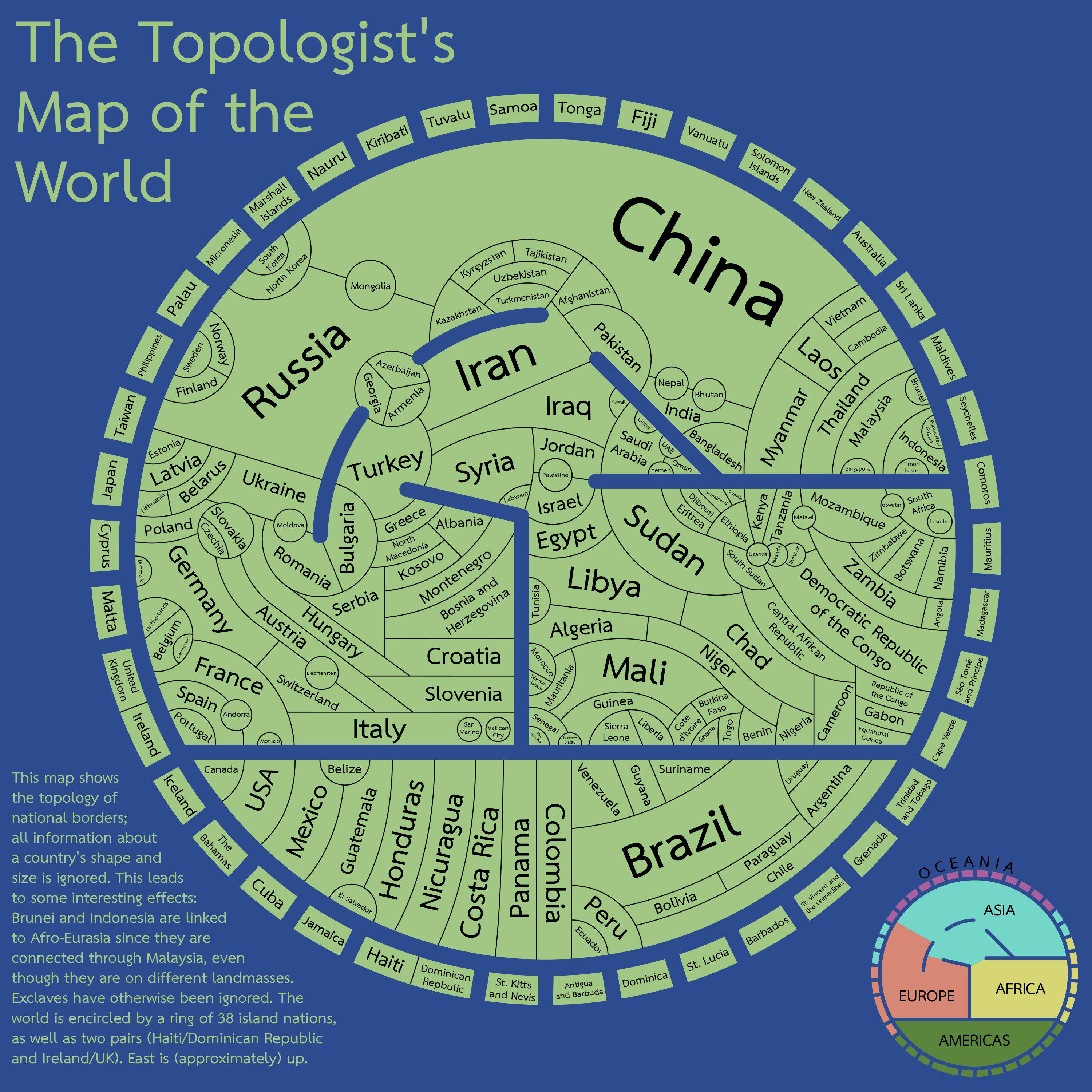
Who’d have thought that Isidore of Seville was actually a topologist fifteen hundred years ahead of his time
Now that’s interesting.
Interesting that this map does have Palestine (presumably the West Bank and east Jerusalem) but doesn’t consider Gaza part of Palestine.
That’s quite a unique combination.
Edit: looking at Azerbaijan, I think they just focus on the biggest landmass and ignore exclaves.
Edit2: the fine print actually says that they ignore exclaves, except for Malaysia.
Maybe it’s just considering de facto control? Israel currently controls the whole Egypt-Palestine border, so there’s no land controlled by any form of Palestinian government that has a border with Egypt
Edit: or it’s an artifact of the “exclaves have otherwise been ignored” part, if the West Bank is considered the core and Gaza is an exclave of that
The West Bank contains both the claimed capital of Jerusalem and the seat of government of the Palestinian Authority in Ramalla. This means Gaza is an exclave.
Like all maps, this one needs a date. For example, Canada and Denmark now share a land border (Hans island)
Exclaves are ignored for this map.
Bolivia shares a border with Argentina. They got that wrong on this map.
And Paraguay does not share a border with Chile. Some South American shenanigans to be sure.
It’s all rightfully Paraguay anyway. /s
France has a land border with Brazil - in fact, it’s its longest border with any country. But I realize that non-contiguous countries pose quite a challenge for this type of layout.
France also borders… Canada. (They have a little island on the east coast)
Denmark (greenland) and Russia also border Canada.
That’s why the text on the left says that exclaves are ignored.
It’s funny looking at the islands, because if you look at the Caribbeans, especially Cuba, they’re close to the nearest continental country, so you might assume at first that they made it work that way for all Islands, and then as you keep going around it keeps getting worst until you have Japan next to Lithuania.
proof that russia is just a buffer state between norway and north korea
Exclaves have been ignored :(
I was looking for the French-Brazilian border, or the Spain-UK one.
San Marino, Vatican City, Liechtenstein, Andorra, Mongolia, Nepal, Bhutan, Palestine and Lesotho all have in common being landlocked countries with one or two bigger countries surrounding them. If I’m not mistaken, all of them have somewhat differing political systems to the countries surrounding them.
It’s facinating to see, that only Lichtenstein seems to have to cross 2 countries to reach the ocean for trading.
Uzbekistan as well since the Caspian Sea is not an ocean.
It made me think about that “maps only need 4 colors” (I don’t remember the proper name, but it’s an idea that maps with political borders can paint every state/country/whatever using 4 different colors and you’ll never get the same color bordering another), seems like the perfect opportunity to see if it applies here
It’s the Four Color Theorem.
And well, it’s actually mathematically proven, but not for maps with disjointed regions that need to be colored the same, such as Alaska + mainland USA.
(In that particular case, it’s not too difficult to resolve, but you don’t get a guarantee for it.)The map in the post actually merges such disjointed regions, though, so it absolutely should work there.
Here’s a way to do it https://i.imgur.com/YULx0sg.jpeg
East Africa and the Balkans took a little bit of figuring out
Edit: and sure enough, there’s actually a mistake in East Africa. DR Congo and Tanzania shouldn’t be the same colour. I think it can be fixed with the following changes:
- Eritrea, Somaliland, and Kenya > green
- Djibouti and Somalia > blue
- Ethiopia > red
- Tanzania > cyan
- Zambia > blue
- Mozambique > red
- Malawi and Eswatini > green
I’m fascinated by this. Also, Nicaragua is spelled incorrectly.
That’s actually quite cool. Its nice how the world’s geography is reflected in the broad structure of the map (as it’s have to be I presume).
could have done better with islands :/
they could have been placed in blue lines by making them a little larger
What have they done to the sweet, sweet Caribbean??
deleted by creator
Is this only land borders? The US and Russia share a maritime border
That would be the blue line. A bit confusing with an identically blue background.
Not even land borders. It’s missing France-Brazil, UK-Spain, and France-Netherlands at the very least.


