
Wyoming: capital is in the small area of useful farmland, as opposed to non-arable mountains. Also close to Colorado, which has a lot more useful farmland and general economic activity.
Nebraska and Kansas: capital is close to the Missouri River, where a lot of trade occurs.
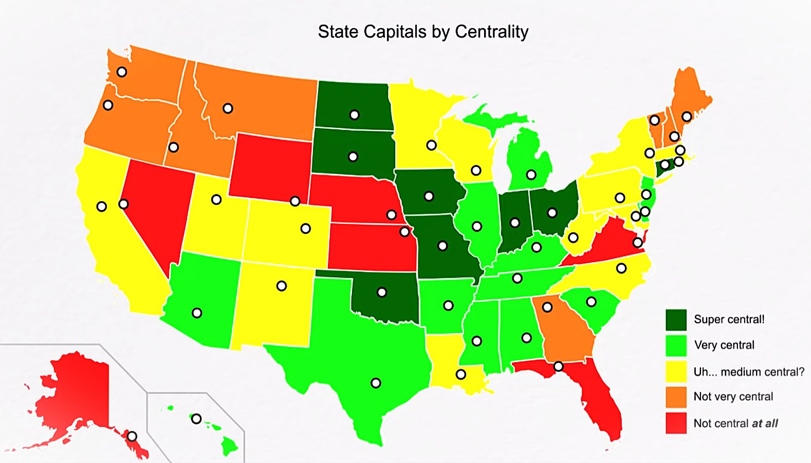
Virginia: capital is
close to DC.not where this map indicates.Florida: ??? I guess it’s just generally closer to the mainland.
Alaska: Capital is far south for the relatively tropical climate.
I’m trying to understand where OP thinks Richmond is located. Potshot, but that looks like it would be near dhalgren VA which is nowhere near the capital.
I’d also argue it’s close ish to the capital. More central ish while still being near one of our major rivers source: I live in Virginia.
Yeah, looked it up and OP looks more like Norfolk or Williamsburg.
Also DC is further north than I thought 🤐
It’s weird how many people have no idea where richmond is. I live in virginia and haven’t met anyone who thinks it’s where this map shows, but I have met multiple people who insist it’s in northern virginia by fairfax until you show them a map. And to make matters worse they all actually live fairly close to richmond but just don’t know they do
I find this so hard to believe. Like how does anyone live in Virginia and not know where Richmond is? I-95 literally runs through the city cutting it in half. If you can find the interstate you will find Richmond. Source: born and bred Richmonder.
I genuinely have no idea, one of them actually got in an argument with another one of my friends about it and started claiming that the map must be mislabeled because richmond couldn’t possibly be south of where we were
I don’t know why this amuses me as much as it does. It’s deliciously ridiculous.
I think it is because people know that a ton of fighting happened between Washington and Virginia during the Civil War, and the area became infamous for the chaotic fighting between both cities. The map seems to have Richmond located on Williamsburg, which isn’t right, but Richmond isn’t very far from there
The ports of Pensecola and St Augustine served as the capitals of East and West Florida territories in the years before Florida became a unified state. The delegations trying to unify Florida got tired traveling all the way to and from each capital so they met in the middle at the site of a destroyed Apalachee settlement (courtesy of Andrew Jackson a few years earlier) and threw up a crude government building
If you overlay a population density map of alligators and sneks, Florida’s capital placement will probably make more sense.
The Yoopers of Michigan take exception to their color choice.
I’m sure all 15 Yoopers are livid. /s
Yeah, lansing itsn’t the best location for the capital given the state is cut in half by lake Michigan-Huron.
Vermont’s dot representing its capital is very misplaced. It’s substantially too far north.
Same for Georgia.
NH’s is a little too SE
Woah, didn’t know the northeast kingdom was the capital. Go Johnson! Truly in Vermont, you do what you want.
It would be nice if the map also revealed the geometric center.
Either California should be green because Sacramento is geographically central, or Washington should be yellow or green because Olympia is central to a majority of the population. You can’t have it both ways.
Ohio did move its capital a few times before landing in Columbus
Same with Indiana.
South Dakota moved from Yankton, on the Missouri River, to Pierre, which isn’t even on an interstate.
That’s not where Denver is located
Brunswick is the capital of Maine? Who knew?
You need to move DC to Kansas.


