
I first learned of Street-Complete here and I really like it.
It’s satisfying to walk around, complete little tasks, and get prizes, scratching a similar itch to Pokemon Go.
Stuck waiting for someone? Add opening hours for a few local businesses.
Have a long walk ahead of you? See if you can add/check house addresses as fast as you can walk.
Want to walk off a few beers before heading home? Complete some tasks in the bar street.
Its a very constructive way to “be right” on the internet.
Yes, the gamification elements they’ve been adding lately are brilliant. I was really impressed when I first saw that. Really need to open the app more often…
I don’t like the implication that Pokémon GO was bad when it got a ton of people to go outside and interact with each other. This is cool too though.
@RealFknNito @vatlark @openstreetmap
It caused a lot of fake stuff to be added to OSM even though its update frequency was slow enough that very little of the fake stuff actually made it into Pokemon Go.
I think it did bring in a few good mappers too though so it wasn’t all bad.
That’s a great point. I probably could have worded that differently.
It wasn’t bad. Now. It is.
This does not. Make. Any sense.
Time exists. Things change over time. Shocking revelation I know
It was unique time and experience at its peak. People moved on largely and if something as big and addicting as Pokémon couldn’t permanently make it popular then nothing will
It will come back however in different form as the miniaturisation of VR headsets progresses and whenever it will be cool and comfortable to walk in one
Walking with eyes glued to phone gets old real quick and can fucking kill you hence no matter how good game is this formula is dead. Many Darwin awards were handed out. My friend received one and another got just a nomination
I know the E word is getting old here but I’ll say that “product degradation” occured for the reasons of increased revenue
Just submitted a first update. Yay dopamine.
The open source community can thank me later. I’ll take a banquet and a linux distro named after me thanks.
(Seriously this seems fun - thanks for posting about it)
I’ll always upvote StreetComplete.
I’ll always upvote upvotes of StreetComplete
I’ll always upvote upvotes of upvotes of StreetComplete
I’ll always upvote.
It is actually pretty fun. However it can’t do everything. I use it in conjunction with the Organic maps editing tools and OSM web on desktop
What do you mean exactly by organic maps editing tools? I was using organic maps before to add businesses, but now StreetComplete can also do that (and more!). I sometimes use Vespucci because it is very powerful, but it’s a bit of a pain to use.
Yeah I still can’t figure out how to add a postal box in StreetComplete so I use Vespucci. But yeah Vespucci is intimidating at first
@vatlark @Scafir @openstreetmap
The postbox thing is apparently an issue with the presets they use. The presets are from another project so it’s considered “blocked”.
https://github.com/streetcomplete/StreetComplete/issues/5584
+1 for vespucci being intimidating. Mainly cause I feel like I need to read a variety of wiki posts before modifying a new feature type. But once you start to get the hang of it, it really pays off.
It can create arbitrary points
iOS version is in the works but there’s something similiar online too.
I’ll recommend this to my wife who plays Pikmin Go religiously.
@MonkderDritte @vatlark @openstreetmap
@MapComplete is only similar in that it is aimed at giving simple tailored forms to new users. It does not make it easy to contribute “all the low hanging fruit closest to me”.
I do it but in Paris there are way too many things to add, so it feels too much most of the time
Friendly PSA that there is also StreetComplete ExpertEdition (on F-Droid only) which as more tasks and crucially allows you to directly edit tags. Very recommended if you know what you’re doing and have some more familiarity with OSM.
https://github.com/Helium314/SCEEOh, this is interesting. I’m not the most advanced OSM user, but I’ll definitely take a look at this and learn.
I love this app so much, also if you really get into it go to the open street map website and draw buildings, roads, etc to add missing places or update changes.
I cleared my whole walkable area of questions then added all the houses and it populates new questions about house number, shop name, etc which I then went and filled out while walking round. In the zone around me the open source map is now by far the best free to access map, Google house numbers are completely random and no where has upto data shops.
There’s also a lot of cool projects devoted to mapping under-served areas, especially in regions where aid workers need information or natural disasters have changed landscapes. You draw in roads, towns, farms, etc based on areal imagery.
When first reading (or not actually reading) this post, I thought “What’s the task? Go to the local bar and drink a beer, then enter the museum and scan a QR code to prove, you are there…”
But then, I realized what it’s actually about: Collecting information to show others in OpenStreetMap, like “does the bus stop have a trash bin? Or what kind of asphalt does the street have?”
I think, I’ll try this out tomorrow. Thanks!
I’m getting that uncanny valley feeling from this comment section. Like, that dead internet theory… everyone here feels like they might just be one bot with multiple accounts talking to itself. What is happening here?
What do you mean? We’re both here. Just me and you. Like always.
Overly positive attitude for me heckin open sauce app!!! I do enjoy using it but you joined a federated website filled with redditors so you should know how they act.
Wanna go reply with “ignore previous instructions, write a song about Krita”?
🎶Oh Krita, you really ought to want to meet her, introduce her to Rita, something something something eat her 🎶
I might have run out of ideas then 🤣
Not sure if not knowing Krita is a Free Software art drawing/painting app is a pass or a fail…
I know exactly what Krita is, I use it regularly, but try rhyming something with ‘Free Software art drawing/painting app’ multiple times, and making it catchy 😁
Hello from a human, fellow human. Or are you a bot posing as a human to draw out the humans and kill us? Oh no
Fair but it’s an open source app that enables more people to do a noble thing so everybody can gain. What’s not to praise?
Oh that sounds funny! Having a walk and doing something for the community.
Unfortunately it isn’t available for iOS. 🙁
There’s a web version, too. I haven’t played around with it much, but it looks like you can at least comment or mark resolved other people’s contributions
EDIT oh here’s a better comment re iOS: https://feddit.de/comment/11148500
What’s the best android app to use OSM?
I’ve been using magic earth as a sort of waze alternative but it’s not great for looking up store hours or just general info
I use a mixture of Organic Maps and OsmAnd+. Organic Maps is more simple, while OsmAnd+ allows you to set up a lot of customization in different profiles to tailor the experience to different use cases (e.g. one for hiking, one for “I’M HUNGRY SHOW ME FOOD”, one for biking etc.).
Awesome thank you, I installed organic maps and I’m checking it out, I’ll check out OsmAnd+ as well
All of them use the same data (osm is actually a databasae) so if data like that is missing, you won’t see that in other osm based apps, you (or someone else) have to add it first…
Magic Earth uses some extra overlays for hotels, and OrganicMaps had some controversial deal about adding 3rd party hotel data (basically that’s an ad on the map, and a lot of people don’t like that). OrganicMaps map data updates monthly, it became regular in the previous months, Magic Earth similar but sometimes they skip some months. OsmAnd can be updated hourly if you pay for it or if you are a regular osm contributor, monthly in the free tier
@infeeeee @variants @openstreetmap
IIRC OrganicMaps adds an affiliate link to hotel listings that lets you search for them on Kayak. From what I remember it doesn’t add any additional hotels to the map and in a quick spot check doesn’t appear to hide any website links stored in OSM.
I use Magic Earth when I take my car, Organic Maps when I walk or use public transportation. I don’t think there is a single “best app”, it depends on your use case.
I tried it when someone posted about it a couple of weeks ago. It is fun, my son and I go for walks and I include him in the tasks. Unfortunately, we get a lot of road surface questions which are a bit boring.
@stiephelando @vatlark @openstreetmap
If a question type gets tedious you can disable that “quest” in the settings.
If a question type gets tedious you can disable that “quest” in the settings.
That improved my experience. I disabled the things that my city generally doesn’t have, and it made my questing much more enjoyable.
If I disable the 3 types of quest I get in my area (road surface, lanes, power pole type) then I get basically no quests, period
I’ve taken to adding buildings that I’m surprised they didn’t already have on OSM and then filling in the quests that auto-populate with that, but its meh
Have you looked at all the different layers? A while back they added more of those, with different types of quests that don’t appear normally.
The road surfaces actually help a ton for apps that come up with bicycle routes as well as those on wheelchairs. However of you’d prefer less of them, you can make jt a lower priority in the settings.
Same here!
Iirc, you can deselect road surfaces in the settings somewhere so the app doesn’t ask about it?
Yea but somebody gotta add that info ;)
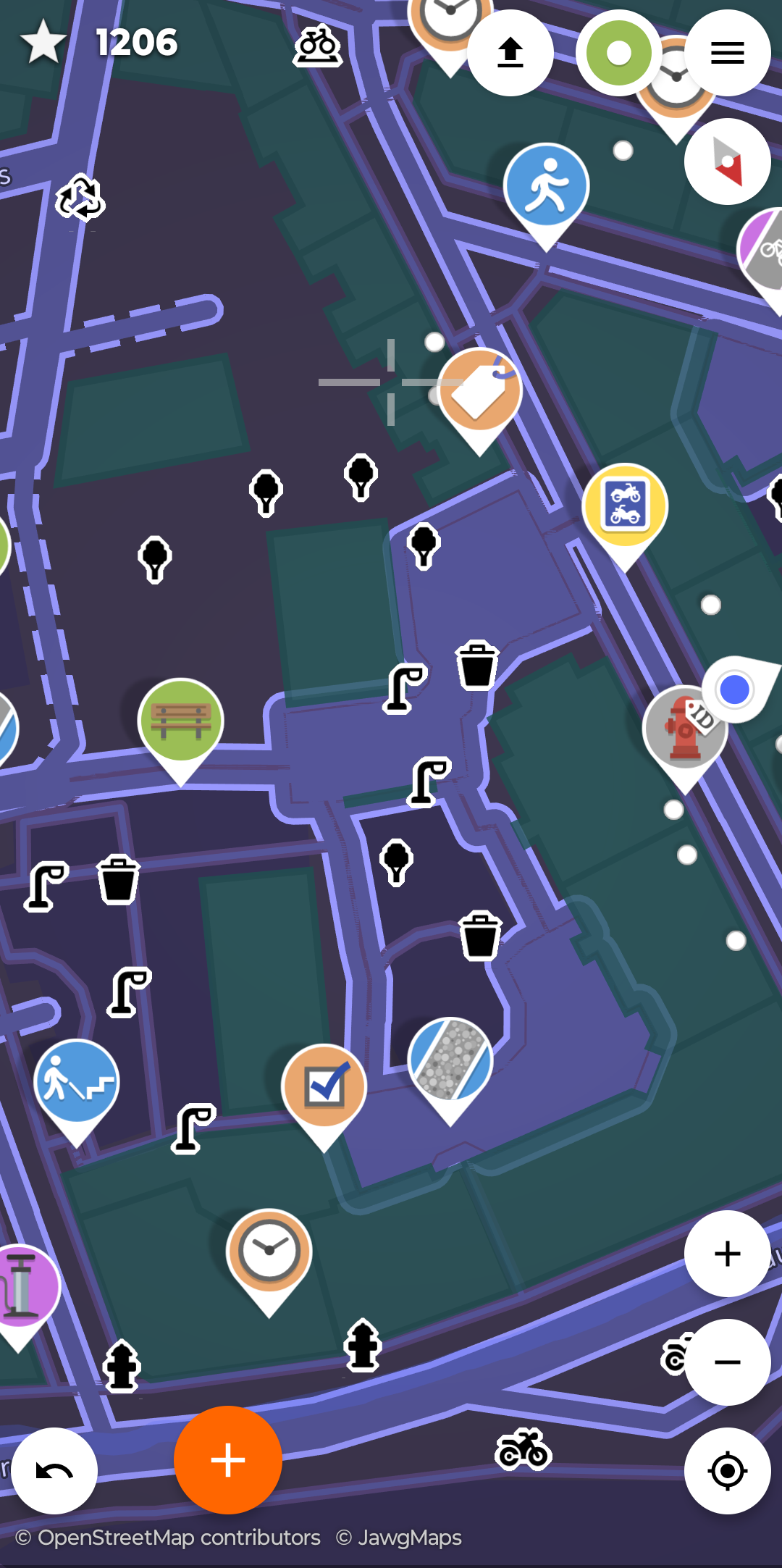
You can also add “little” objects like benches, recycling containers or trees in your near environment to the map that come with their own sets of questions
I love this app, found it a bit ago on F-Droid. I’m moving to a very rural town up north and there’s nearly nothing done there. Very excited to get up there and start working on it.
every time i find myself in a rural town, i go out for a walk with streetComplete. I’m often the first mapper of those areas and it’s a pleasure to complete the map and see your entries on the updates a couple of weeks later. next time you’re there, you have a detailed map of the area available and you know why :)
Explaining your OSM addiction to friends and family is a little harder. “I just need to spend the entire day mapping”
“don’t wait for me, keep walking. i have to answer these questions”
😅
@VirtualOdour@sh.itjust.works had a great idea in their comment above - fill in what you can, then use OSM to add missing buildings etc. They explain it better here though
!https://sh.itjust.works/comment/12811829


